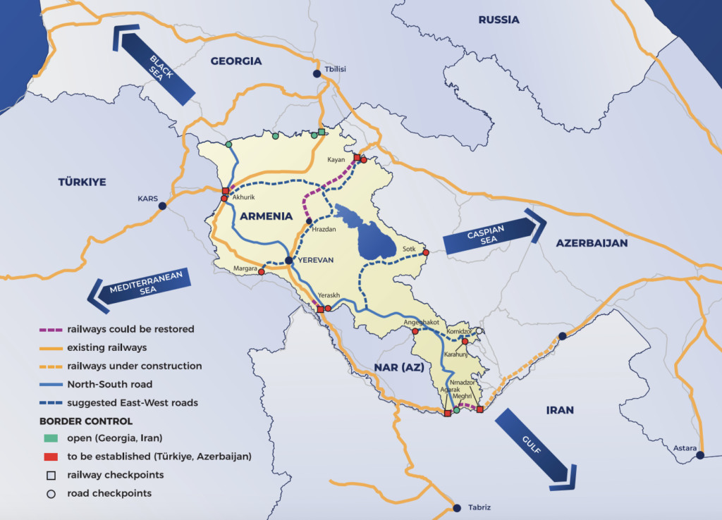
Syunik is considered the most strategic of Armenia’s provinces. The second largest of Armenia’s provinces (behind only Gegharkunik, most of whose territory is occupied by Lake Sevan), Syunik forms a crucial lifeline towards Iran, one of Armenia’s only two open borders. The province is also uniquely vulnerable – territories of Azerbaijan are situated to both its west and east, forming a corridor that is only 25 kilometers wide at its narrowest point. This vulnerability was underscored during recent Azerbaijani offensives, with an Azerbaijani attack in the mountains above the village of Ishkhanasar in November 2021 and another assault towards the mountain resort town of Jermuk in September 2022. Both campaigns resulted in Baku’s occupation of Armenian territory.
Against this background, Armenia’s transit infrastructure in Syunik province has assumed greater strategic importance. In particular, there has been a need to develop alternative transit routes in the wake of the 2020 war, which resulted in numerous major roads becoming unusable as territory once held by Armenian forces was ceded to Azerbaijan. These roads include Armenia’s primary north-south highway, a stretch of which crosses the Azerbaijani border between the Armenian cities of Goris and Kapan. Despite the gravity of the situation, there has been a lack of information on which routes are still accessible and whether the Armenian government is succeeding in its ambitious plans to replace and renovate these roadways.
The most significant of the roads in question is the M2 highway that connects Yerevan to its border with Iran. As mentioned, parts of this highway, previously the primary route from the Iranian border to central Armenia, passed under Azerbaijani control in the months following the 2020 war. ISA traveled to both Goris and Kapan to ascertain whether cargo trucks still used the road by paying Azerbaijani toll fees, and whether transit along the road is possible at all. After these visits, ISA can confirm that traffic along the M2 highway between Goris and Kapan has halted. Traveling south along the M2 from Goris, an Armenian border post south of the village of Karahunj blocks any further movement down the road. Azerbaijani and Russian posts are visible several hundred meters further down the road, and an Armenian border guard confirmed that the road is completely closed to traffic. From the other direction, traveling along the M2 highway heading north from Kapan, there is a joint Armenian-Russian base and roadblock present at the village of Karmrakar and the entrance to the village of Davit Bek. Armenian border guards at the post told ISA that it would theoretically be possible to reach the village of Shurnukh about 15 kilometers further north along the road, but that special NSS permission was required, and that the road was ‘not entirely safe.’ It appeared that access may still be possible for Shurnukh locals, but not for the general public.
In a rushed attempt to replace this critical motorway, Armenian authorities upgraded an alternative route through central Syunik – which stretches from mountainous Tatev and Kapan to Meghri. As of November 2021, the Kapan-Tatev section of the new route had been renovated with commercial-grade asphalt, reducing travel time from two hours down to just 40 minutes, according to a resident of Tatev. But the new route faces challenges, primarily the prevalence of tight hairpin turns around Tatev. These conditions made the road unfit for heavy cargo trucks. Another Tatev local, speaking in November 2021, reported ‘one to two accidents every day’ on this section of the road.
In light of the route’s challenging terrain, the Armenian government built a new road linking the village of Ltsen with Tatev directly, thereby bypassing the hairpin section entirely. At the time of writing, the new north-south Ltsen-Tatev highway is fully active and hosting international cargo traffic. The new road begins at the main Yerevan-Goris highway, turning off southwards towards the village of Noravan. From there, it proceeds through the Vorotan river gorge, heading southeast about five kilometers east of the city of Sisian. Active construction was occurring near the village of Vaghatin. The road then passes the village of Ltsen, continuing for about 20 kilometers before reaching the village and monastery of Tatev. Large numbers of Armenian, Iranian, Georgian and other trucks were visible on the road, which was completed prior to the winter of 2023-24, according to a local in Tatev. However, there are two small difficulties with this road. First, numerous sections were littered with small and medium-sized rocks from landslides and rockfalls, the result of no nets having been placed upon the many rock faces that line the road. Second, the new route is roughly 30 to 40 minutes longer than the old Goris-Kapan road. Nonetheless, the benefits of the Tatev-Ltsen bypass road far outweigh these minor hurdles.
Another roadway that came under Azerbaijani control in the aftermath of the 2020 war lies immediately south of Kapan. This stretch of road, about four to five kilometers, connected Kapan with the village of Chakaten before continuing southwards, passing through a string of villages — Shikahogh, Srashen and Tsav — before eventually reaching the Araks river. The Kapan-Chakaten road is now unusable, with Armenian border guards stationed at its northern and southern ends. Recently, a new Kapan-Chakaten roadway has been built parallel to the older one and is fully functional. While there is very little traffic along the full length of the road (from the Araks to Kapan), as civilian and cargo traffic from Iran largely uses the Meghri-Kajaran-Kapan road, the road is in good condition.